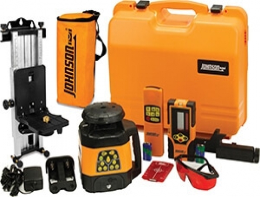
JOHNSON LEVEL ELECTRONIC SELF LEVELING HORIZONTAL & VERTICAL ROTARY LASER LEVEL KIT
- Share on social media
Johnson's 40-6534 Rotary Laser Level with Integral Vertical Mount is great for indoor and outdoor construction laser levels - carpenters, plumbers and electricians LOVE this rotary laser level for the versatility and accurate leveling it provides. Self leveling both horizontally and vertically, with a Vertical mount. Johnson's 40-6534 rotary laser can be used for a number of indoor and outdoor applications, including leveling, checking cut and fill, setting foundations and footings,Septic tanks and basement excavations, Acoustical ceiling and drywall installation, aligning and plumbing walls, Contour framing and more.
Features:
Electronic self-leveling and designed for outdoor use
Reinforced metal roof and glass enclosed beacon
Electronic beam shield to turn the laser beam off from one to three quadrants for multiple laser usage
Vibrate mode ignores slight movements as in windy conditions
Electronically-controlled dual slope feature
Visual and audible alarms when beyond leveling range
Rotary Laser Specifications:
Laser beam color — Red
Operating range without laser detector — 200' diameter
Operating range with laser detector — 1,500' diameter
Accuracy — ±1/8" at 100'
Rotation speed — 200 and 500 rpm
Self-leveling? — Yes
Self-leveling range — ±5°
Slope — ±5°
Power supply — Rechargeable NiMH battery pack, 6V adapter or 4 C alkaline batteries
Ingress protection rating — IP54 (equipment is protected against dust and splashing water)
Operating temperature — 14°F - 113°F
Includes:
Rotary laser with NiMH rechargeable battery pack
Charger for rotary laser
Alkaline battery compartment for rotary laser (batteries not included)
Laser detector with battery and clamp
Remote control with battery (40-6740)
Multi-function mount
Tinted glasses
Magnetic target
Hard carrying case
3 Year Manufacturer's Limited Warranty
| Town / City / village: | Harper - Liberia |
| Creation Date | 20.01.2022 |
| Ad number: | 21435 |
| Category | Electronic devices |
| Keywords: | Total Stations, Theodolites, Levels, Laser Levels, GPS/GNSS Surveying, Data Collectors |
Send a message to user


Our recommendations and advices
In general we believe that all our announcer and services providers are genuine. But In order to avoid been fooled and for your own personal safety, always meet the seller in a public places or at least not in isolated places. It's probably a good idea if you bring a friend as well to witness the transaction
Other Ads from this advertiser More similar ads


Other Ads that may also interest you More similar ads